
My Visit to Kotor
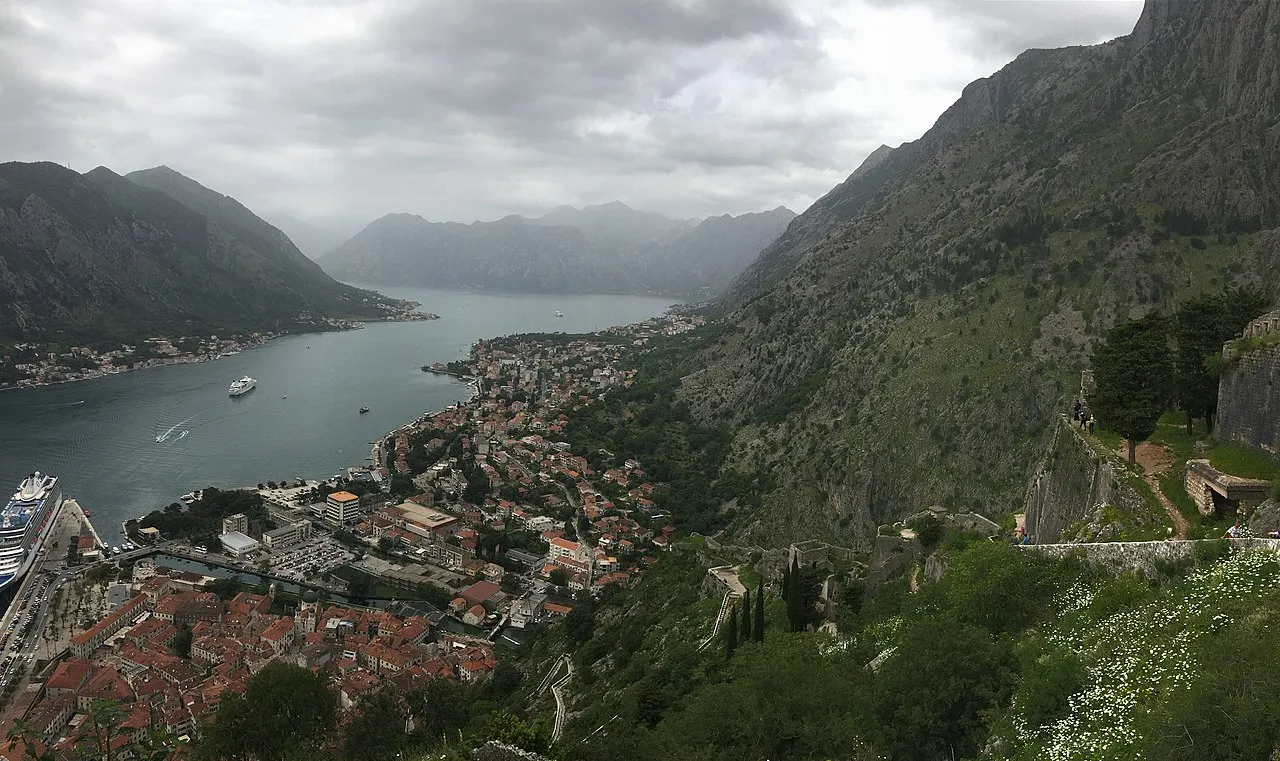
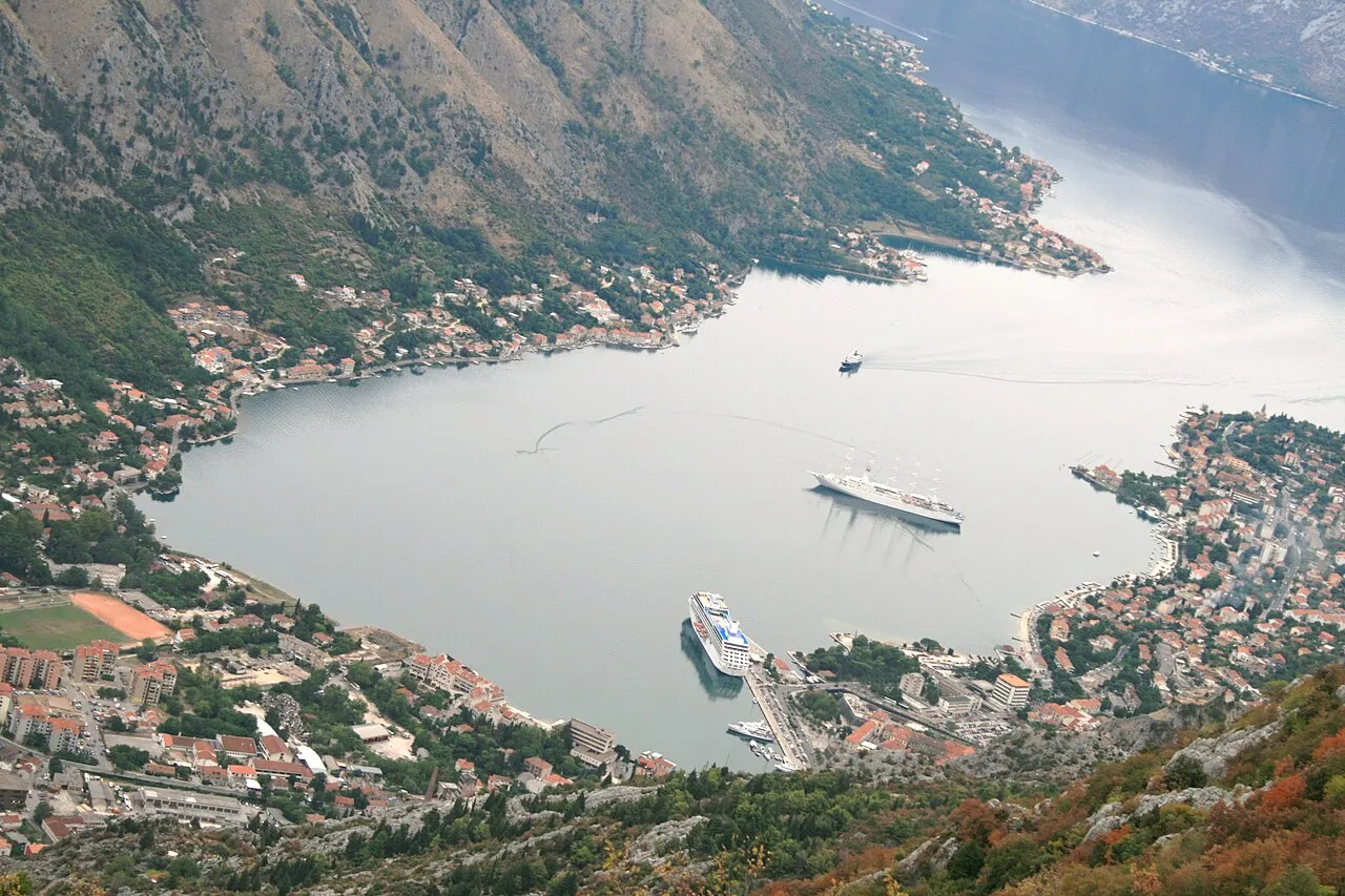
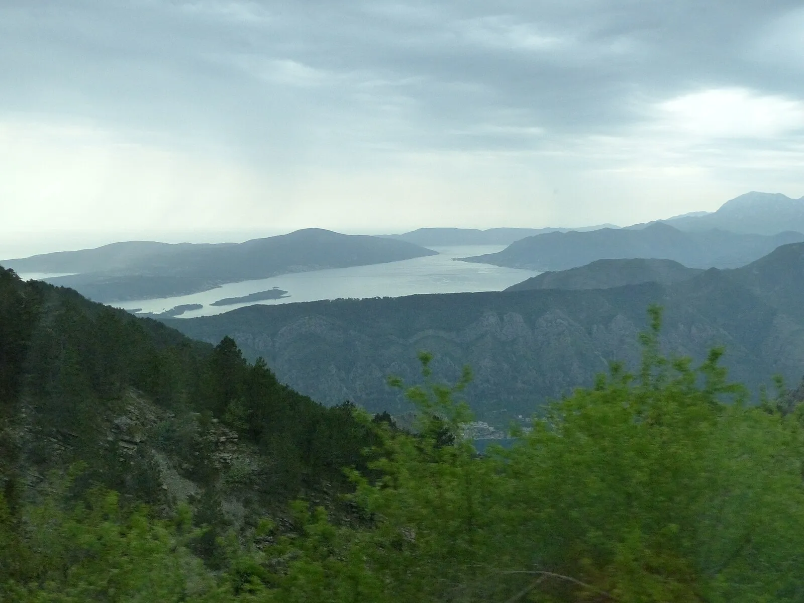
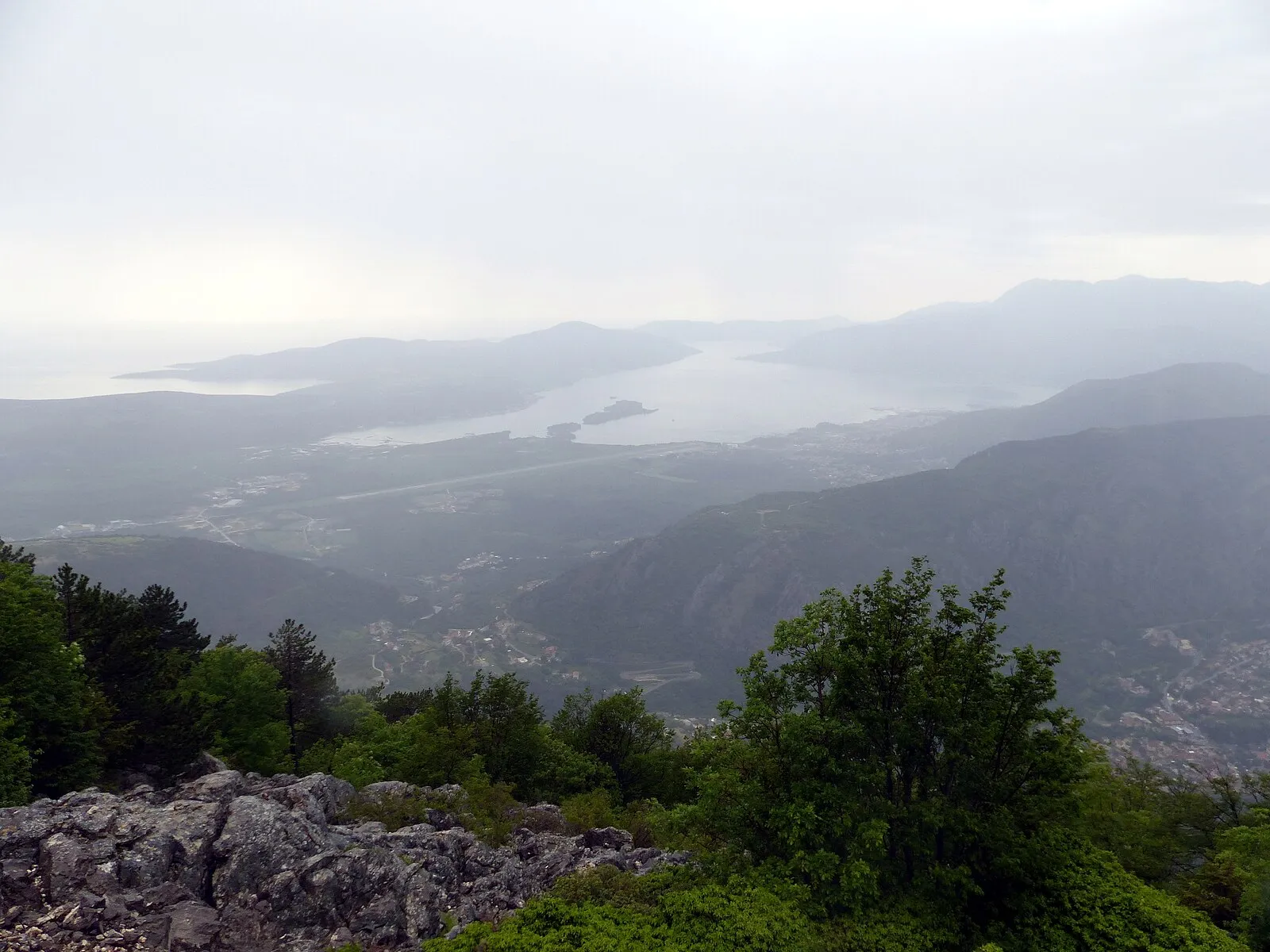
I woke before dawn and climbed to the upper deck in bare feet, the steel cold against my soles, the air carrying a salt-and-pine scent I had never encountered on any other morning at sea. Our ship was gliding through the Verige Strait, only 330 meters wide, and on both sides the mountains of Montenegro rose nearly 1,900 meters straight from the water into a sky turning from charcoal to pale rose. I stood at the rail and watched in silence as the Bay of Kotor opened before us — 28 kilometers of winding, fjord-like waterway that the Adriatic had carved into limestone over millennia. The sound of the bow cutting through still water was the only noise. No engine throb reached this high. Just the hush of the sea and the distant echo of a church bell from somewhere deep in the bay. My wife joined me, wrapped in a blanket, and we said nothing for a long time. Some approaches demand words. This one demanded quiet.
They call it Europe's southernmost fjord, though technically it is a ria — a submerged river canyon drowned by the sea. The distinction matters to geologists but not to anyone standing on deck at first light, watching limestone cliffs glow pink and gold as the sun finds them. This is a double UNESCO World Heritage site, designated in 1979 for its Natural and Cultural significance and again in 2017 as part of the Venetian Works of Defence. Our ship docked right at the Old Town — literally at the Sea Gate. No tenders, no buses, no waiting. We stepped off the gangway and into the 12th century.
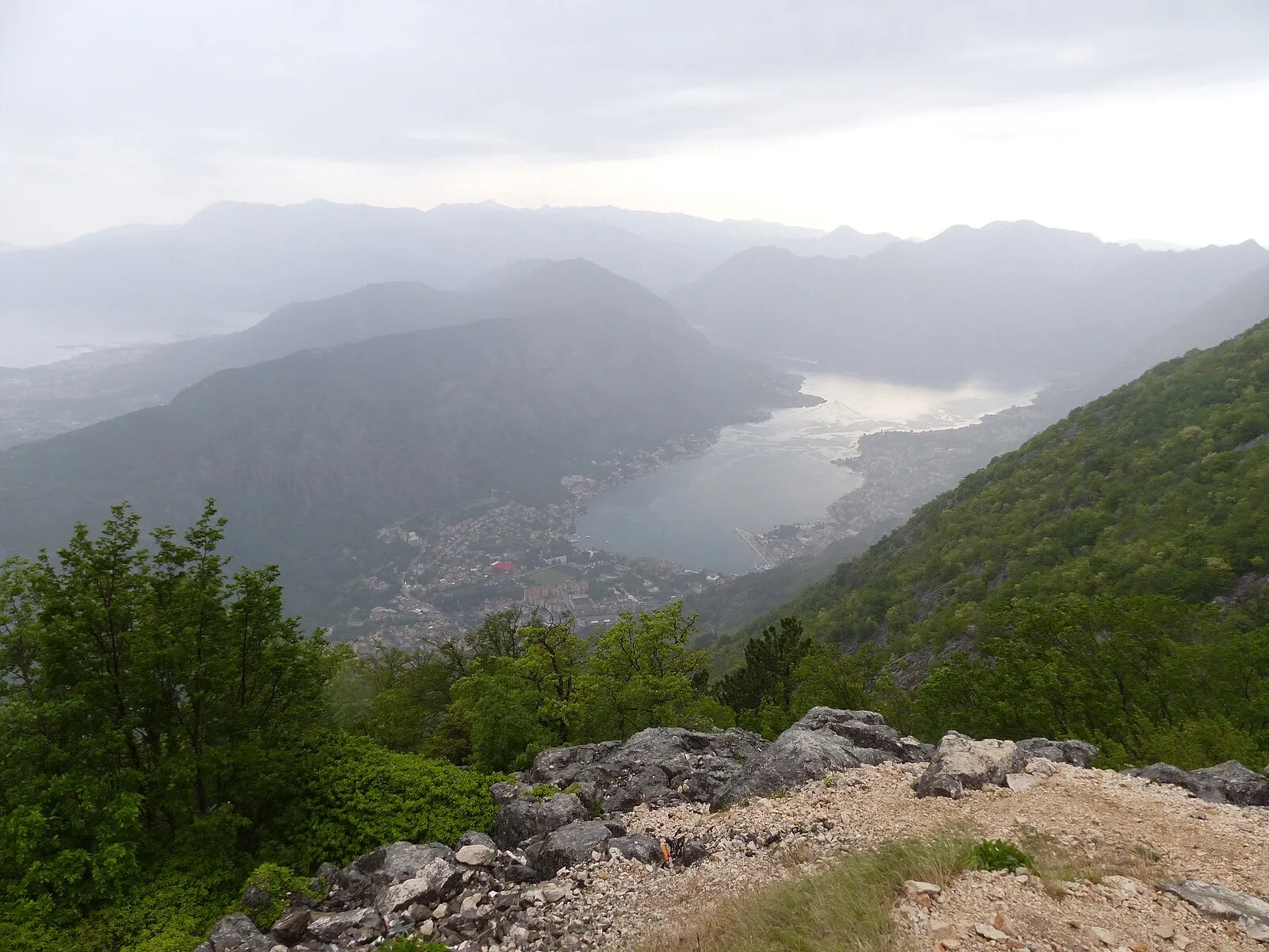
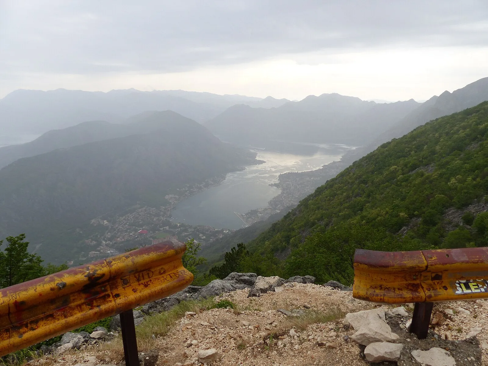
I started the fortress climb at eight in the morning, while the stones were still cool beneath my palms where I steadied myself on the walls. There are 1,350 steps winding up to San Giovanni fortress, climbing roughly 280 meters above sea level. The fortifications snake 4.5 kilometers around the mountainside, some sections 20 meters high and between 2 and 16 meters thick — walls built to withstand Ottoman sieges and Venetian ambition alike. My legs burned by the halfway point. My shirt was soaked through. I stopped at a ruined chapel perched on a ledge and drank the last of my water, watching a hawk circle below me. Below me. That is the strange gift of this climb — the world inverts, and you find yourself looking down at birds. The scent of wild rosemary rose from the stones whenever I brushed against it, sharp and clean and alive.
At the top, I turned around and my breath caught. The ship looked like a toy far below. The red roofs of the Old Town spread out like spilled rubies against the blue of the bay. The entire waterway stretched to the horizon, bending through its narrow passages, and I could see why sailors had been seeking shelter here since 168 BC, when Roman merchants first called this place Acruvium. I sat on a warm stone and felt tears run down my face — not from the effort, though my lungs were still burning, but from something I could not name. Perhaps it was the scale of it, how small I was against those mountains, how brief my time against those centuries of stone. Perhaps it was gratitude for the simple gift of being alive in such a place. I whispered a prayer of thanks and let the wind dry my cheeks.
The Byzantines fortified Kotor in 535 AD under Emperor Justinian, recognizing what the Romans knew: whoever controls this bay controls the southern Adriatic. Then came Serbian rule, then an independent republic, and finally the Venetians in 1420. For nearly four centuries Venice shaped every stone archway, every colonnade, every winged lion carved into the walls. You can see the layers if you know where to look — Roman foundations beneath Byzantine towers beneath Venetian facades, all still standing, all still inhabited. I traced my fingers along a doorframe in the Old Town and felt the grooves worn smooth by eight centuries of hands.
Down in the Old Town, the Cathedral of Saint Tryphon anchors the main square, its twin Romanesque bell towers catching the morning light exactly as they have since it was consecrated in 1166. The interior was dim and cool, smelling of centuries of incense and stone. I stood before the relics of Saint Tryphon — the city's patron — resting in a silver reliquary that survived the devastating 1667 earthquake, and I thought about endurance. About the things that survive. The cost to enter was only €3, but what I found inside was worth far more than any price.
In the afternoon, we took a speedboat to Our Lady of the Rocks and Perast. The man-made island church is tiny and perfect — built on a reef that fishermen expanded over centuries by sinking stones and old ships. The water taxi cost €5 per person from Perast, and the ride took only ten minutes, but stepping onto that island felt like stepping outside of time. We swam in water that was 18 degrees and felt cold against our sun-warmed skin, yet so clear I could see the bottom four meters down. We had dinner at Konoba Catovica Mlini, a restaurant built inside a converted stone mill — mussels in buzzara sauce that tasted of garlic and the sea, so good we ordered a second portion for €12. The waiter smiled and said, "Everyone does."
Kotor feels undiscovered compared to Dubrovnik, even though it is not. The Old Town can be crowded when multiple ships are in port, and yet there is something about the scale of those mountains, the depth of that bay, that makes the crowds feel small. However busy the streets become, you only need to look up. The mountains are always there, silent and enormous, reminding you that this place was ancient before anyone thought to visit it for pleasure.
Looking back, I realize what Kotor taught me. It is not the fortress at the top or the cathedral at the bottom that stays with me, though both were extraordinary. What stays is the climb itself — the burning legs, the rough stone under my hands, the moment when I finally understood that the reward was not the view but the effort to reach it. Sometimes the most valuable things in life are the ones that cost you something. Not money, but sweat and breath and the willingness to keep going when your body says stop. My wife met me at the bottom with a cold bottle of water and a quiet smile. "Was it worth it?" she asked. I could not speak for a moment. I just nodded. It was worth every step.
Weather & Best Time to Visit
Featured Images
The Cruise Port
What you need to know before you dock.
Kotor's cruise port sits directly beside the medieval Old Town, making it one of the most convenient port setups in the Mediterranean. Larger ships anchor in the bay and tender passengers ashore, while smaller vessels can dock at the main quay just 100 meters from the Sea Gate. The tender ride takes approximately 10 minutes. There is a small tourist information kiosk near the landing area with free maps, and ATMs are located just inside the Old Town walls. The pier area is largely flat and wheelchair accessible, though the Old Town itself has uneven cobblestones. Currency is the euro, and credit cards are accepted at most restaurants and shops. English is widely spoken in tourist areas. The port area has limited shade, so plan accordingly during summer months when temperatures can reach 35 degrees Celsius.
Getting Around
Transportation tips for cruise visitors.
Walking: Kotor Old Town is compact and entirely walkable — most key sights are within a ten-minute stroll of the Sea Gate. The main squares, Cathedral of Saint Tryphon, maritime museum, and waterfront cafes are all close together. Streets are cobblestone and can be uneven, so sturdy walking shoes are essential. The Old Town is largely flat, but the fortress climb is strenuous and not accessible for guests with limited mobility. The waterfront promenade outside the walls is smooth and level, making it comfortable for wheelchair users and pushchairs.
Local Buses: Public buses run from outside the Old Town to Perast (€2, about 20 minutes), Budva (€4, about 30 minutes), and other bay towns. Buses are reliable during summer but less frequent off-season. The bus stop is a five-minute walk from the port.
Taxis: Metered taxis wait near the Old Town entrance. A taxi to Perast costs about €15 one way, to Budva about €25. Agree on the fare in advance for longer journeys. Taxis can accommodate mobility aids with advance notice.
Water Taxis: Small boats shuttle visitors from the Kotor waterfront to Perast and Our Lady of the Rocks. Cost is approximately €5 per person each way. A scenic and efficient way to see the bay from water level. Departures are frequent during cruise season.
Organized Tours: Both ship excursions and local operators offer bay tours, Budva trips, and Lovcen National Park drives. Local operators along the waterfront typically charge €30-50 per person for half-day tours, offering more flexibility than ship-organized options.
Kotor Port Map
Interactive map showing the cruise terminal, Old Town, fortress walls, and Bay of Kotor. Click any marker for details.
Excursions & Activities
How to spend your time ashore. For popular activities, book ahead during peak season to secure your spot. Many visitors choose to explore independent of the ship excursion options for flexibility and cost savings, though a ship excursion offers guaranteed return to the vessel before departure.
San Giovanni Fortress Climb
The signature Kotor experience: 1,350 steps climbing 280 meters to the ruins of San Giovanni fortress. The fortifications span 4.5 kilometers with walls up to 20 meters high and 2-16 meters thick, dating from Byzantine times through centuries of Venetian rule. The official entrance fee is €8, though early risers sometimes find the gate unattended. Allow 2-3 hours round-trip. Start before 9 AM to avoid the worst heat and the cruise ship crowds. Bring at least one liter of water per person — there are no vendors on the trail. The climb is strenuous and not suitable for those with mobility difficulties, but the panoramic view from the summit is one of Europe's finest. This is a moderate to high-energy activity that rewards patience and sturdy footwear.
Bay of Kotor Boat Tour & Perast
A boat tour of the bay visits the Baroque village of Perast and the man-made island church of Our Lady of the Rocks. Independent visitors can take a local bus to Perast for €2, then a water taxi to the island for €5. Ship excursion versions cost €50-80 per person and typically include a guided narrative of the bay's Venetian history, plus stops at multiple towns. The island church contains a remarkable collection of votive paintings by local sailors. Perast itself is car-free, with crumbling Venetian palazzos and waterfront restaurants serving fresh seafood at reasonable prices.
Kotor Old Town Walking Tour
The walled Old Town is a UNESCO treasure of Romanesque churches, Venetian palaces, and medieval squares. Key stops include the Cathedral of Saint Tryphon (€3 entry, consecrated 1166), the Maritime Museum (€4), and the many small churches tucked into narrow lanes. The town is famous for its cats — there is even a cat museum. Allow 2-3 hours for a thorough exploration. Free to wander; guided walking tours cost about €15-20 per person from local operators near the Sea Gate.
Budva Old Town Day Trip
The walled beach town of Budva sits about 25 minutes south by taxi (€25) or 30 minutes by bus (€4). It has sandy beaches, a lively riviera atmosphere, and a compact old town with medieval walls and churches. A good option for visitors who want a beach day combined with some history. Ship excursions to Budva cost €40-60 per person and often combine it with a panoramic bay drive.
Lovcen National Park
For those with a full day, a taxi or organized tour to Lovcen National Park (about 90 minutes by car) offers dramatic mountain scenery and the mausoleum of Montenegrin ruler Njegos at 1,657 meters elevation. The 25 serpentine hairpin bends climbing from Kotor are legendary. Organized tours cost €40-60 per person. Not recommended for those who suffer from motion sickness on winding roads.
Depth Soundings Ashore
Lessons learned the hard way — practical tips before you step off the ship.
Fortress Water: There is no water for sale anywhere on the 1,350-step fortress climb. Bring at least one liter per person, two in summer. The cost of forgetting this is real — dehydration at 280 meters elevation with no shade is no joke.
Timing the Crowds: When three or four ships are in port simultaneously, the Old Town's narrow streets become genuinely congested. Start early or wait until late afternoon when day-trippers begin returning to their ships. The fortress climb is quieter before 9 AM.
Cobblestone Reality: The Old Town streets are beautiful but uneven. Flip-flops and heels are a poor choice. Sturdy walking shoes with good grip will save your ankles and your dignity. The polished limestone becomes slippery when wet.
Cash for Small Purchases: While most restaurants accept cards, water taxis, small vendors, and the fortress entrance fee often require euros in cash. An ATM is located just inside the Sea Gate.
Perast Bus Return: If you take the local bus to Perast independently, confirm the return schedule before you go. Off-season service can be infrequent, and missing the last bus means an expensive taxi ride back.
Photo Gallery
Frequently Asked Questions
Q: Is Kotor worth visiting on a cruise?
A: Absolutely — it is one of Earth's most dramatic cruise ship sail-ins. A double UNESCO World Heritage site (Natural and Cultural 1979, plus Venetian Works of Defence 2017), with a medieval walled Old Town, 1,350-step fortress climb, and one of the most beautiful bays in Europe. Founded as Roman Acruvium in 168 BC.
Q: What is the best thing to do in Kotor?
A: The San Giovanni fortress climb is the signature experience — 1,350 steps to 280 meters elevation for panoramic bay views that are genuinely among Europe's finest. Then visit the Cathedral of Saint Tryphon (consecrated 1166) and take a boat to Perast and Our Lady of the Rocks.
Q: How long does the fortress climb take?
A: Allow 2-3 hours round-trip for the full 1,350 steps. Start at 8 AM to beat heat and crowds. The fortifications span 4.5 km circumference with walls 2-16 meters thick. Bring plenty of water as there are no vendors on the route.
Q: Can you walk from the cruise port to the Old Town?
A: Yes — when ships dock at the main quay, the Sea Gate is literally 100 meters from the gangway. When ships anchor in the bay, a tender brings you to the waterfront, and the Old Town is a one-minute walk from the tender landing.
Q: Is Kotor accessible for visitors with limited mobility?
A: The waterfront promenade and port area are accessible for wheelchair users. However, the Old Town has uneven cobblestones, and the fortress climb is strenuous with no accessible alternative. The bay boat tours are a good option for those who want scenic views without the physical demands of the climb.
Q: What is the best time of year to visit Kotor?
A: Peak cruise season from May to September offers the warmest weather and longest days. However, July and August can be very hot for the fortress climb. May, June, and September offer the best balance of warmth and manageable crowds.
Q: What should I pack for a port day in Kotor?
A: Sturdy walking shoes are essential for the cobblestones and fortress steps. Bring sunscreen, a hat, and at least one liter of water for the climb. A light layer is useful for church visits where shoulders must be covered.
Image Credits
- Hero and gallery images: Wikimedia Commons (CC BY-SA)
- Logbook and featured images: Wikimedia Commons (CC BY-SA)
Images sourced from Wikimedia Commons under Creative Commons licenses.
Tender Port
Ships anchor offshore and passengers take small boats (tenders) to reach the pier.
Last reviewed: February 2026
Key Facts
- Country
- Montenegro
- Region
- Bay of Kotor
- Port
- Kotor (tender port; smaller ships dock at main quay)
- Currency
- Euro (EUR)
- Language
- Montenegrin
- Climate
- Mediterranean; hot dry summers, mild wet winters
Author's Note: Until I have sailed this port myself, these notes are soundings in another's wake — helpful for planning, and marked for revision once I have logged my own steps ashore.